The northern South Island is known as Te Tau Ihu, the prow of the waka from which the demigod Māui fished up the North Island. Marlborough is strongly associated with the earliest period of settlement in Aotearoa. Early Polynesian settlers—migrants from Hawaiki in East Polynesia—inhabited Te Pokohiwi/the Wairau Bar in the thirteenth century.
Successive migrations of people were drawn to the region’s rich resources. Earlier tribes were largely displaced by Ngāti Kuia and Ngāti Mamoe in the sixteenth century, with Ngāti Mamoe dominating the Wairau. Later in the century, groups of Rangitāne moved southwards from the Hawke’s Bay via Wairarapa, while Ngāti Apa migrated across from the Rangitīkei district. Rangitāne eventually consolidated their position in the Wairau and in the 1700s created an 18-kilometre network of channels amongst the estuarine coastal lagoons. This massive engineering feat served them to harness the already plentiful mahinga kai resources, including fish, eels and birds. In the 1820s a whaling industry centred on Cook Strait was established, with Māori working, trading and intermarrying with Pākehā whalers at shore whaling stations in the Marlborough region.
Between 1828-1832 the settled alliances of the region were unbalanced when a war party of Kawhia and Taranaki warriors armed with muskets attacked numerous pā. This caused great losses among the local populations, especially Rangitāne and Ngāti Apa. Ngāti Toa Rangatira put down roots in the Wairau and one of their warrior chiefs, Te Rauparaha, dominated affairs in the region; Ngāti Rārua also settled along the Wairau River. In October 1839 it was primarily with Ngāti Toa that William Wakefield negotiated to purchase large tracts of land for the New Zealand Company, who needed the rural arable pastures of the Wairau Valley to support their colony at Nelson.
Ownership and possession of the Wairau was still in dispute in 1842 when the New Zealand Company persisted with surveying the valley, despite Te Tau Ihu chiefs’ denial of Ngāti Toa’s claims to the area, and Te Rauparaha’s insistence that the Wairau land was excluded from the Company’s purchase. The unrest erupted into violence on 17 June 1843, when a posse of settlers tried to arrest Te Rauparaha and his nephew Te Rangihaeata in retaliation for their disruption of the surveying. The confused fighting resulted in the deaths of around 25 people, including victims from both groups.
Shockwaves from this tragedy, today referred to as the ‘Wairau Incident’, were felt locally and nationally, and attempts to secure the Wairau slowed until after Commissioner Spain’s 1845 inquiry into the land claims of the Nelson area found that the Wairau District had not been included in the 1839 sale. By various devious and underhand coercive tactics the Crown finally wrested possession of the Wairau from Ngāti Toa in 1847, and the valley was divided into allotments.
The 2008 Waitangi Tribunal inquiry report, and subsequent Treaty of Waitangi settlements, acknowledged the Crown’s failure to protect iwi rights and interests in its methods of acquisition of Wairau land and failure to provide adequate reserve lands, among other breaches. Today Rangitāne o Wairau, Ngāti Rārua and Ngāti Toa Rangatira have principal interests in the Wairau/Blenheim area.
Blenheim emerges from the wetlands
The name of the region’s major river, ‘Wairau’, derives from ‘Ngā wai-rau o Ruatere’, describing the braided waterways across the region, highly important to Māori for providing food and resources such as flax as well as a communication/transport network. The large flax swamp at the convergence of the Ōpaoa and Omaka rivers was described by the area’s Māori name, Te Waiharakeke. This swamp, the future site of Blenheim, also inspired that settlement’s first European name, ‘The Beaver’, said to have been coined by Joseph Ward (1817-1892) when he came across his surveying party ‘[sitting] like a lot of beavers in a dam’ amidst floodwaters.
Blenheim developed in the 1850s. Earthquakes in 1848 and 1855 gave the future settlement a boost (literally and figuratively) as the ground level dropped enough to allow sea-going vessels to sail up the river to the site, increasing its potential as a trading nexus. Merchant James Wynen built a raupo warehouse there sometime soon after 1848. In 1852, James Sinclair and his family became the first to permanently reside there. From 1857 Sinclair was the land agent who marketed the town sections. By 1865 Blenheim was the principal town in the province, with a steadily growing population.
Catholicism in Blenheim
Catholicism in Aotearoa New Zealand grew from the work of missionaries who arrived in Northland in 1838. Bishop Jean-Baptiste Francois Pompallier’s mission was notable for its efforts to form Catholic belief around existing Māori tikanga and disseminate teachings by printing books in the Māori language. The Māori name for Catholicism, ‘Pikopō’ (from ‘episcopal’, meaning ‘of a bishop’), reflects Pompallier’s impact. The missionaries established the Society of Mary’s work in Aotearoa. In 1850 a split between Pompallier and the Society of Mary led to the creation of the Diocese of Wellington, which became the base of the Marist clergy, and included Blenheim.
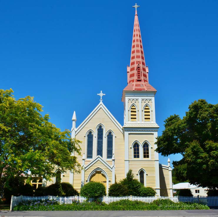
In 1844 the first Catholic missionary visited Marlborough. Father Antoine Garin (1810-1889) was the first Parish Priest, appointed in 1850. However, Father Augustine Sauzeau SM (1834-1898), appointed Marlborough’s Parish Priest in 1864, is considered the founder of the Parish of St Mary. Sauzeau built the first St Mary’s Church on a large site in Blenheim’s Maxwell Road, opened on 26 September 1865. The Blenheim church was part of Sauzeau’s program to establish Catholic facilities in the Marlborough region; the same year he opened the first Catholic School on the Blenheim site. By 1876 a new, larger building was needed to replace the old church. Sauzeau engaged prominent Wellington architect Thomas Turnbull, who designed a substantial timber Gothic building. The new church was opened on 29 September 1878. The first St Mary’s church building was then used as a girls’ school until 1909, then a meeting room until its demolition in 1926.
Housing the Religious: the Convent
The Sisters of Mercy were brought to Blenheim by the parish in 1885 and contributed much to the community through their work as teachers at the Catholic schools. The Order, founded by Catherine McAuley in 1831 in Dublin, had been brought to Aotearoa in 1850 by Bishop Pompallier in response to a request from wāhine Māori for ‘wāhine tapu to teach and care for their people’. The first Sisters in Blenheim lived in a temporary convent set up the original presbytery cottage across Maxwell Road from the church. A property adjacent to the church across Francis Street was purchased for a future convent to be purpose-built once funds were raised.
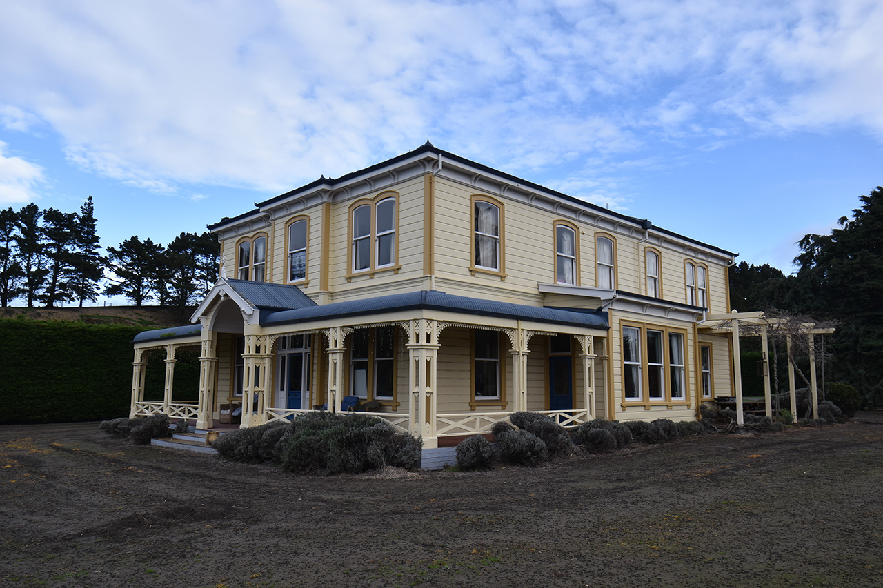
The building of the convent—named St Joseph’s—was instigated by Rev. Father Louis Claude Servajean S.M., in August 1900. The architect of this original stage of the impressive residence is unconfirmed. Servajean is known to have made rough sketches for a building costed at £1000, which is in the ballpark of its final cost as built by local timber merchants Bythell & Co. If based on Servajean’s sketches, architectural assistance would still have been required. Thomas Turnbull and Sons have been attributed, possibly on the basis of their 1878 commission for St Mary’s Church; D.A. Douglas is another possible architect, as the street-facing façade of the building bears a strong resemblance to his work on the 1891 St Mary’s Presbytery. The foundation stone of the two-storey, 12-roomed timber convent was laid on 8 December 1901 by Archbishop Redwood once £850 pounds had been raised, and when it opened on 15 June 1902 it was free of debt thanks to donations from Servajean’s French relatives. A detached music room in the grounds was also under construction in 1902, and the lessons given there became a valued part of the convent’s income.
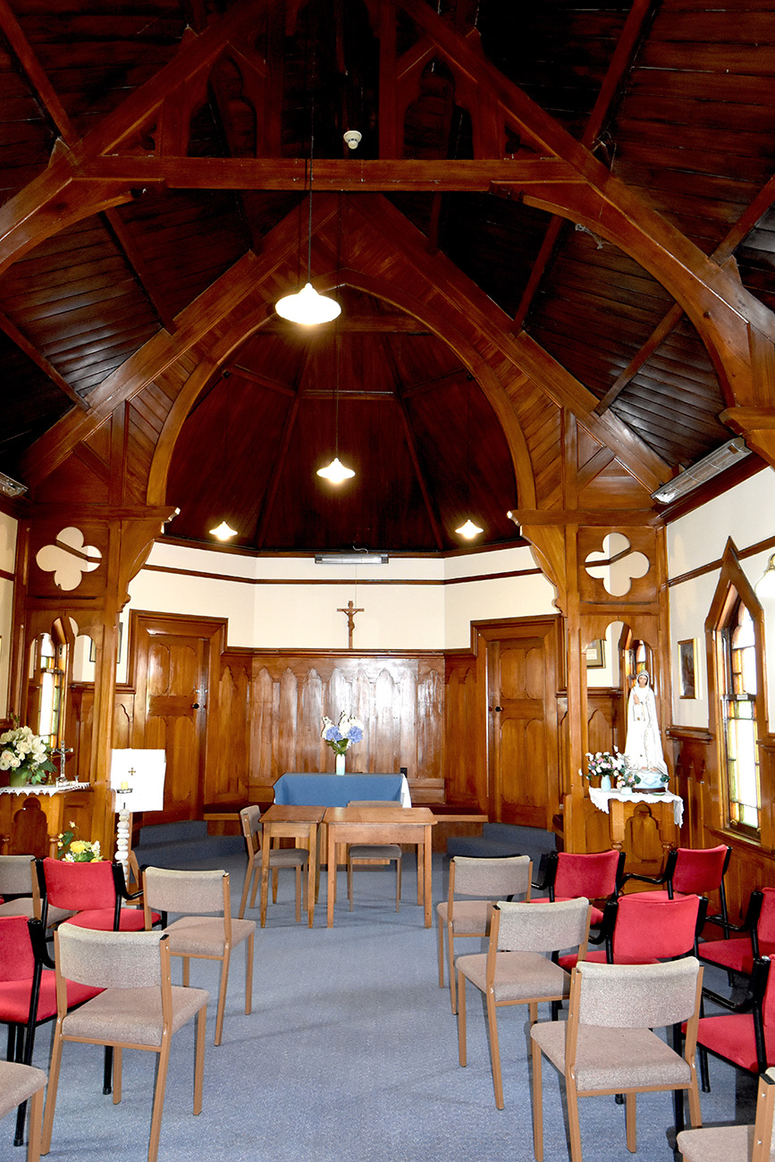
A new wing, including a chapel on the top floor for the private use of the Sisters, was added to the convent in late 1909. Designed by Wellington architect John Sydney Swan, the chapel was modelled after his 1908 design for St Gerard’s Catholic Church in Wellington. Swan was, at the time, amidst a series of significant commissions for the Catholic Church in New Zealand, which ultimately also included Erskine College, Our Lady of Compassion Convent in Wellington, Sacred Heart Convent in Whanganui, and St Bede’s School in Christchurch amongst other smaller buildings and additions. Swan’s design for the Blenheim convent chapel was described as ‘Large and roomy, the decoration has been most artistically treated.’ Polished rimu stalls for the Sisters ranged round the room; the floors and ceilings were polished matai and the altar rails were polished brass topped with cedar. Light filtered through coloured cathedral-glass windows and globe-shades fitted over the electric lighting. An anteroom (sacristy) also featured cathedral-glass windows and rimu panels. An Imperial organ from Dresden was gifted to the chapel by Father Holley.
The ground floor of the wing contained a community room with battens of rimu decorating the ceiling, and a couple of ‘nice and airy’ cells. The balcony of the original building was extended to meet the new wing and the refectory and kitchen were also extended by 6 feet. The detached music room was repositioned further away from the building. At the time, ten Sisters were resident in the convent. In subsequent years the number of bedrooms was increased to 19 or 22, requiring the enclosure of upstairs balconies, and in 1930, an addition to the rear of the building with new bedrooms off a new corridor, above an enlarged kitchen, refectory and laundry.
Convent Schools
The centennial of the St Mary’s convent schools was celebrated in Blenheim on the weekend of 14-15 October 1972. Although Sauzeau had opened the first school soon after his arrival in 1864, the first two purpose-built schools for boys and girls dated from 1872. A high school building was constructed in the convent grounds in 1903. Originally taught by lay schoolmasters, in 1896 the Sisters of Mercy took over teaching duties. The Sisters taught infants, primary and secondary students, until in 1952 the De La Salle Brothers, another Christian order focused on education, arrived to take over tuition at the boys’ primary school. On this occasion 200 former pupils gathered to pay tribute to the Sisters who had had such an impact on their lives.
Over 50 former pupils of the St Mary’s schools have been inspired to enter the religious life. However, dwindling numbers of people entering the vocation of the Order of the Sisters of Mercy brought changes to the parish schools over time. The high school was closed in 1970 because of lack of funds to pay lay teachers’ salaries. By this time only girls were attending, although in the past it had been a co-ed school for Catholics and non-Catholics alike. It was subsequently used by the primary schools until their new campus buildings were completed, then as a Parish Centre.
Changes at the Mercy convent
In 1953, when Rev. Father Leonard Brice SM brought the De La Salle Brothers to the parish to teach at the Boys’ School he acquired a property for them to live in at 73 Maxwell Road, named Delargey House after Cardinal Reginald Delargey (1914-1979). In 1972 the La Sallian Brothers withdrew from Blenheim due to declining numbers. By this time the numbers of Sisters living in the convent had also diminished greatly, and spare bedrooms lay empty. Shortly after the Blenheim Sisters of Mercy celebrated their centenary in 1985 with a gathering of past residents, a deal was struck with the Parish to exchange ownership of the convent with that of Delargey House, and the remaining Sisters moved out and into the smaller home. The former convent building was then renamed ‘Jordan House’ and used as home and base for the St Mary’s Youth Chaplain and his group of youth workers, who worked to foster the Christian faith among teenagers. The Sisters of Mercy’s 140-year presence in Blenheim came to an end in 2019 with the departure of the final two women, Sister Susanna Krause and Sister Elizabeth Mary. A service was held at St Mary’s to pay tribute to the Mercy Order’s long contribution to the community.
Property review 1988-1998: dispersal of the Presbytery and Convent
In the late 1980s the Parish Pastoral Council and Parish Priest Father Michael O’Hagan commissioned a wide-ranging review of Parish property assets. The goal was to reorganise and concentrate resources on revitalising key assets for the future ‘Beyond 2000’; a result was the rationalising of some of the ageing buildings to raise capital. A scheme for a reordered Parish centre on Maxwell Road was devised by architects Calder, Fowler, Styles and Turner, involving major alterations and additions to the church, and construction of a new administration block, hall and presbytery. Despite having been heritage-listed since 1982, the convent and presbytery to the south of St Mary’s Church, along with the convent high school building and music room, were earmarked for disposal; other properties were sold and some school buildings demolished and rebuilt.
New lives for the old building
In April 1994 the convent building was bought by Dr Wilf Holtrop and relocated in five sections to his rural property at 776 Rapaura Road, where it was reassembled for use as a bed and breakfast. The chapel was excluded from the sale and was retained by the church for future use as a cultural centre – it was physically cut from the building, including the floor which supported it. Sir Michael Fowler designed a new addition to take its place on the Rapaura Road building, and construction began immediately. The chapel’s original form was replicated on the new site, including the small gable projecting from the eastern end of the roof, and stained glass windows – likely sourced from the redevelopment at St Mary’s Church – were installed. The balcony was demolished for the relocation and built anew, replicating the original except for the iron fretwork brackets, and the enclosed corner sunrooms were not reconstructed. The balcony was extended around to the east wing to provide a second storey balcony for the new bedroom where the chapel was previously located, and a small new extension to the south elevation replaced part of the 1930s bedroom/kitchen additions. It is likely that some larger bedrooms were created by merging smaller cells at this time. In 2000 the small timber church of St Michael’s was relocated to the property to enhance the venue’s wedding facilities.
As the accommodation business grew, a new lounge was added to the south of the east wing in 2008. Sir Michael Fowler’s ‘billards room’ design echoed the apsidal shape of the adjoining former chapel wing, and featured a panelled ceiling reminiscent of the original building before its renovations. The building’s most substantial alterations, including large additions to the south, were carried out in 2016 during rebranding of the business as The Marlborough luxury boutique accommodation. The entrance area at the south was extended with a new office and commercial kitchen addition adjoining the southwest of the 2008 lounge addition, and a reception lounge was added to the west of the entrance. The previous ‘driver’s bedroom’ and bathrooms were altered into new toilets. The old kitchen and rectory became a new guest room with ensuite, and ensuites were added or refurbished for all of the guest rooms, which now numbered ten with some new rooms created. 2020 again saw additions to the building, with a modern restaurant extension added to the east of the 2008 lounge addition.
Creation of the Mercy Room
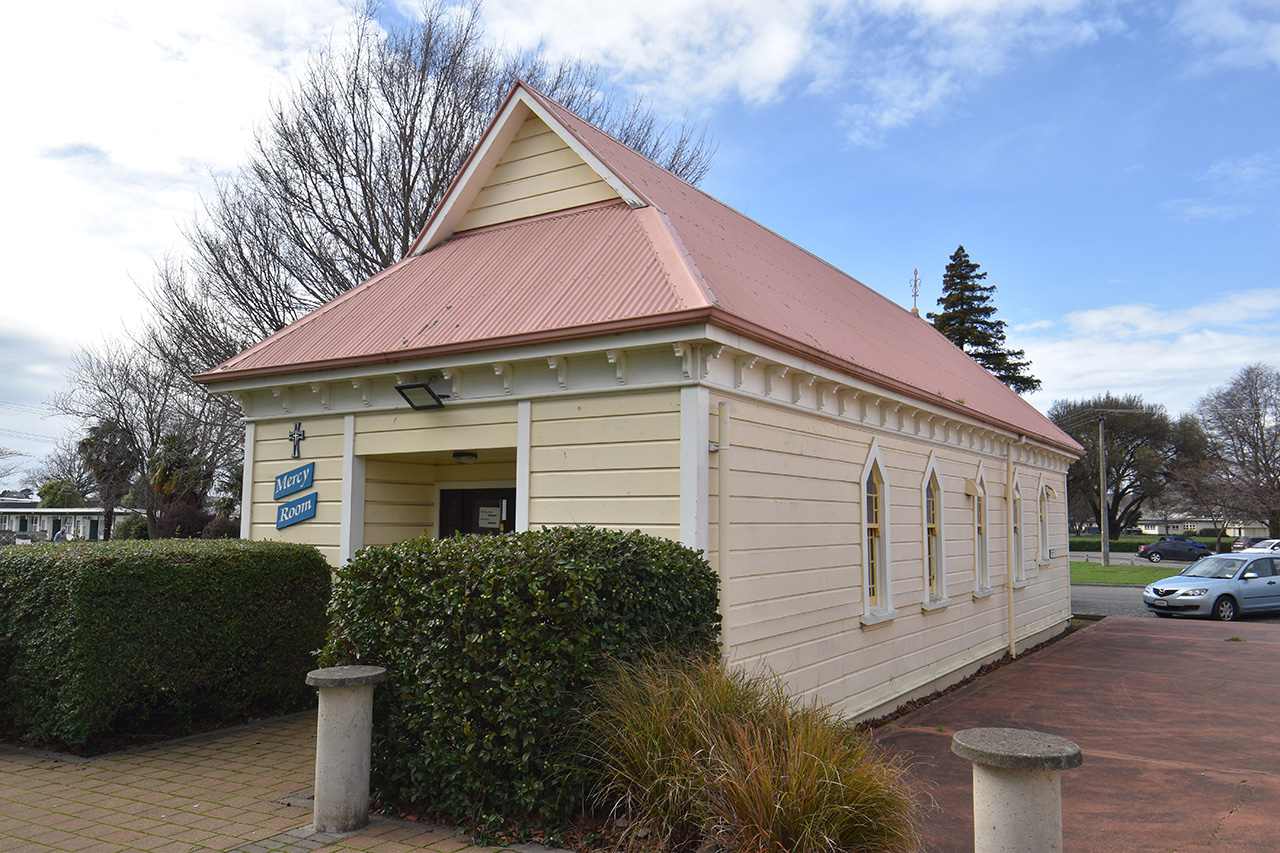
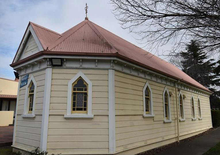
The former convent chapel was left standing in the Maxwell Road grounds for some years, propped on timber blocks, while work was undertaken on the church. The chapel’s openings were boarded up but one of the coloured glass windows was lost to vandalism. As time passed the chapel deteriorated and eventually the parish decided that ‘the cost of restoration was beyond the end value of the building.’ A conservation report outlining options for its repair and reuse was prepared by conservation architect Alexandra Teague, who considered the building to be in generally good condition, especially the interior which was virtually unchanged since construction. Because of the NZHPT classification it received a Lotteries Grant for $24,500 for its reinstatement, including new foundations and a new entrance foyer to enclose the previously internal access point, designed by architect Tim Barton. Originally planned for reuse as a Cultural Centre in the reorganised St Mary’s complex, it was instead renamed the Mercy Room and was used by the Hibernian Society. In recent years it has been used for meetings and for daily Mass, as its smaller size makes it easier to heat than the church.
Sir Michael Fowler’s vision for the Maxwell Road Catholic station was fully enacted and St Mary’s Church continues to be its centre, albeit now surrounded by mostly modern buildings, including its attached foyer and additions, and adjacent Community Centre, new presbytery and administration building. The St Mary’s school buildings have also been modernised to replace the older buildings. The 1878 nucleus of the church, and the former convent chapel/Mercy Room, are now the oldest buildings on the site. The parish, now known as the Star of the Sea Marlborough (Te Whetu o Te Moana), is grappling with updated seismic strengthening requirements for the St Mary’s Church building and is undertaking another property review.